Showers might greet Monday morning commuters
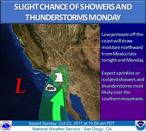
By John C. Toman. Posted October 23, 2011, 7:56 PM.Unstable moisture from off the coast Mexico, unusual for this late in the season, could make for a wet Monday in coastal and inland Southern California. A couple of low pressure systems are interacting to suck unstable mid-level moisture up from the south tonight. It might arrive just in time to snarl Monday morning traffic with some sprinkles or light, isolated showers and a chance of thunderstorms. The total amount of moisture is not that great; less than a tenth of an inch is predicted in most locations. Thunderstorms, if they materialize, could make that greater in some locations. At the lower levels, the marine layer is predicted to thicken Monday morning and then even more on Tuesday morning. A second, colder system is expected to pass through Tuesday, but nothing much more than drizzle is anticipated. Temperatures were expected to fall nearly twenty degrees between Sunday and Tuesday. Sunday was about ten degrees above normal. Tuesday will be about ten degrees below normal. Rainfall, if it materializes, would mark the second time this month that a storm with a sub-tropical component affected the region. The first storm of the month, on October 5th, picked up sub-tropical moisture and doused some of the wildfire potential in what is usually a prime fire season month. 
Monday showers and potential thunderstorms (courtesy National Weather Service - San Diego) |
Other Recent Weather News for WeatherCurrents
|