73°F / 45°F
calm
0.00"
Storm totals: August 11th, 2012
By John C. Toman. Posted August 12, 2012, 11:38 PM.Saturday's surge of monsoonal moisture led to scattered showers and thunderstorms throughout Southern California's inland valleys. Perris was hit the hardest, with pea-sized hail and 0.51" precipitation. Other affected areas included East San Jacinto (0.11"), De Luz (0.08"), Hemet and Murrieta (0.06"), Menifee (0.04"), Temecula and French Valley (0.03"), and Moreno Valley (0.01"). The thunderstorms began at around 12:45pm and continued, off and on, until 7pm, according to Monty Parrot. Microburst damage was reported in Temecula around 3:25pm. Temescal Valley, south of Corona, had tree damage from the storms, and reported winds of 88 mph. From many communities, the sight and sound of lightning and thunder was apparent, going on for minutes at a time. For many locations, the rainfall was the first of a young season. An earlier round of thunderstorms July 11th and 12th marked the other time this summer that significant rainfall came west of the mountains. That round hit hardest between Menifee and Riverside. Sunday's follow-on activity didn't result in any measurable rainfall, but a funnel cloud was generated along the Elsinore Convergence Zone. Here are the rain totals for the WeatherCurrents network and associates:

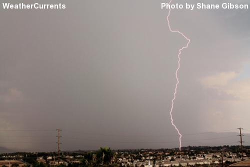
Lightning strike near Murrieta Hot Springs Road and Winchester Road. Photo courtesy of Shane Gibson. |
Other Recent Weather News for Hemet, California
|