By John C. Toman. Posted February 19, 2012, 4:39 PM.
A cold winter storm left the first significant rain totals for February this past Wednesday in Southern California.
The third storm of the week was clearly the strongest, with rain totals between a quarter of an inch to an inch in the inland valleys.
Simi Valley, to the west, had the weakest total, with 0.09" for the storm.
The main swath of showers appeared to run through the middle of Riverside County in the afternoon and evening hours Wednesday. Menifee recorded the most rainfall (1.00"), a surprise, since it is usually one of the driest areas in Western Riverside county.
Other high totals nearby were in Perris (0.74"), East San Jacinto (0.70", courtesy of Monty Parrott), Hemet (0.64") and Beaumont / Cherry Valley (0.63").
It was the strongest storm since December 12th in what has been a fairly dry rain season to date. The low snow levels left a fresh coat of snow on the region's mountain ranges, down under the 4,000 foot level. According to the National Weather Service, Idyllwild, east of the most affected valley communities, had 14" of fresh snow.
Down south, De Luz recorded 0.72". Most of the rest of Southwest Riverside County was between 0.43" (East Murrieta) and 0.60" (Northwest Murrieta).
Rain totals dropped off north of Perris and south of Temecula (0.55").
In San Diego County, Fallbrook registered 0.25" and 0.39" fell in San Diego's City Heights neighborhood.
As of Sunday, no new significant storm was in sight, although there was some chance of system coming through the last weekend of February.
Here are the rain totals for the WeatherCurrents network and associates:
Location |
Storm |
Season |
Source |
Menifee |
1.00" |
4.16" |
WeatherCurrents |
Perris |
0.74" |
3.57" |
WeatherCurrents |
De Luz |
0.72" |
7.90" |
WeatherCurrents |
East San Jacinto |
0.70" |
4.89" |
Monty Parrott |
East Hemet |
0.64" |
4.85" |
WeatherCurrents |
Beaumont (Cherry Valley) |
0.63" |
2.37"1 |
WeatherCurrents |
Northwest Murrieta |
0.60" |
5.31" |
WeatherCurrents |
French Valley |
0.59" |
4.84" |
WeatherCurrents |
South Temecula |
0.55" |
5.12" |
WeatherCurrents |
Wildomar |
0.55" |
4.86" |
WeatherCurrents |
Lake Elsinore |
0.49" |
5.31" |
WeatherCurrents |
East Murrieta |
0.43" |
4.44" |
Reginald Stanley |
San Diego (City Heights) |
0.39" |
0.91"2 |
WeatherCurrents |
Riverside (Canyon Crest) |
0.32" |
3.41" |
WeatherCurrents |
South Fallbrook |
0.25" |
5.81" |
WeatherCurrents |
San Bernardino |
0.24" |
5.10" |
WeatherCurrents |
Moreno Valley |
0.19" |
3.53" |
WeatherCurrents |
Simi Valley |
0.09" |
5.13" |
WeatherCurrents |
- Beaumont's rain record was restarted after re-location of the weather station there.
- The City Heights station began recording rainfall on February 11, 2012.
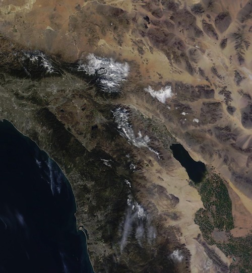
Southern California snowfall from space (courtesy of National Weather Service) |
Other Recent Weather News for San Jacinto, California
-
Storm Totals: September 30th - October 1st, 2023
October 1, 10:44 PM
-
Damp, cooler weather this weekend
September 30, 10:49 AM
-
Tropical Cyclone Java's remnants bring clouds, sporadic light showers to region
September 10, 10:14 PM
-
Storm Totals: August 20th-21st, 2023
August 22, 1:47 AM
-
Hurricane Hilary downgraded to Tropical Storm as of Sunday morning
August 20, 8:27 AM
-
Storm Prediction Center issues slight risk of possible tornadoes Sunday
August 20, 2:33 AM
-
Evacuation Warnings issued for San Bernardino mountain communities
August 20, 1:32 AM
-
Hurricane Hilary: Status Update as of Midnight, August 20th
August 20, 1:06 AM
-
Hurricane Hilary could be the first tropical cyclone to directly impact California since 1939
August 19, 4:15 AM
-
Tropical Storm Warning in effect as Hurricane Hilary approaches from the south
August 19, 3:44 AM
-
Monsoonal moisture brings isolated showers early this week
August 1, 3:29 AM
-
Excessive Heat Warning to remain in effect through Saturday
July 18, 1:42 PM
|