N/A°F / N/A°F
N/A
N/A
A few degrees dip for us; out-of-season storm to the north
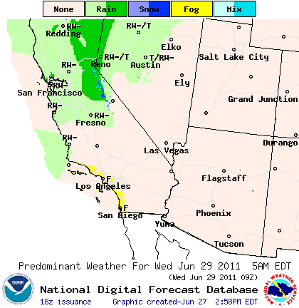
Posted June 27, 2011, 12:44 PM.The wettest La Nina rain season on record is all but behind us, but to the north, they're not done just yet. On Wednesday and Thursday, the inland valleys of Southern California will see warm temperatures drop about five degrees or so, and perhaps some incursion of marine layer in the morning, in the western valleys. To the north, starting in the central coast area past Point Conception, there's a chance of rain from a very late season storm, finalizing what has been an unusual rain season. NWS forecasters over the weekend called the latest storm "impressive," considering the onset of summer, even though the chance of rain aren't very high. The storm is, in essence, a classic winter/spring storm that's out-of-season, sweeping in from the Pacific Northwest. Most summer rain, if it occurs, is from other influences (monsoonal moisture and tropical storm remnants). June is typically the driest month of the year in Southern California. Speaking of monsoonal moisture, hints of them (in the form of high clouds) could begin arriving in California by Sunday, although no thunderstorms are predicted. A stronger surge of moisture is possible next week. 
Graphical forecast for Wednesday, June 29th, 2011 |
Other Recent Weather News for San Bernardino, California
|