Currently
N/A°F
in De Luz, California, USA

N/A°F / N/A°F
N/A
N/A
Sunday, March 15, 2026 7:49 AM PDT
De Luz
Currently
Forecast
Past Weather
Climate
Last 36 Hours
Weather News
Features
F.A.Q.
Contact Us
Use °C/Metric
 RSS Feed
 Follow UsWeatherCurrents
Local Roundup
Mobile Access
On Your Site
Follow UsWeatherCurrents
Local Roundup
Mobile Access
On Your Site
Rosa Fire Photos
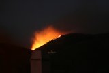
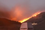
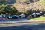
Posted October 27, 2007, 7:28 PM.The following photos of the Rosa Fire were taken from the Temecula Valley as the Rosa Fire broke out on October 23, 2007. The Rosa Fire was one of two Riverside County fires that broke out during late October's Santa Ana winds. The other was the Roca Fire in Aguanga, about 10 miles east of Temecula. Thanks to Douglas Leany for providing the photos. If you have additional photos of the Rosa Fire or any other fires, please submit them. Temecula
|
Other Recent Weather News for De Luz, California
|