
N/A°F / N/A°F
N/A
N/A
Storm totals: July 31st, 2011
By John C. Toman. Posted August 1, 2011, 8:33 AM.It was the second round of monsoonal storms to send rainfall down on Southern California's inland valleys this summer, but Sunday's thunderstorms produced the first widespread precipitation of the new season, almost a half of an inch in some locations. Showers began early on Sunday morning, just after midnight in many locations. The heaviest rainfall came later, however, with raindrops in the 5am hour accompanied by thunder and lightning, and again in the 11am hour, especially in the easternmost communities of Hemet and Beaumont. The National Weather Service reported a couple hundred lightning strikes in the Inland Empire and Coachella Valley Saturday night and Sunday morning. The rain totals reflected the origin of most summer rainfall: from the southeast, a reversal of the normal winter fortunes. Hemet topped sixteen WeatherCurrents stations with 0.43", followed by Beaumont at 0.26", then Menifee and Riverside at 0.25". Other significant rainfall totals were: East San Jacinto (0.21", courtesy of Monty Parrott), Perris (0.19"), De Luz (0.17"), Temecula (0.16"), San Bernardino (0.14"), French Valley (0.14"), East Murrieta (0.12", courtesy of Reginald Stanley), Lake Elsinore (0.10") and Fallbrook (0.10"). To the west, in Ventura County, Simi Valley received no measurable rainfall to rank at the bottom of Sunday's thunderstorm heap. Other local totals, compiled from the National Weather Service, included 0.16" in Valley Center (San Diego County), 0.58" in Devore (San Bernardino County), 1.17" in Lake Arrowhead (San Bernardino Mountains), 0.35" in Palm Springs, 0.29" in Corona, 0.32" in Garner Valley (San Jacinto Mountains), 0.51" at Santiago Peak (Santa Ana Mountains), and 0.27" at Palomar Mountain. The rain season in California began on July 1st. The following rainfall totals were recorded Sunday:
Notes: WeatherCurrents' Jurupa Valley station was offline due to technical difficulties during the thunderstorms. 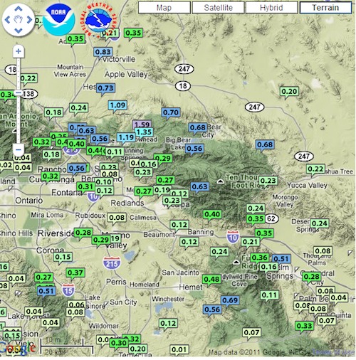
Sunday thunderstorm totals (Alex Tardy, National Weather Service) |
Other Recent Weather News for De Luz, California
|