Currently
N/A°F
in De Luz, California, USA

N/A°F / N/A°F
N/A
N/A
Friday, April 19, 2024 11:46 AM PDT
De Luz
Currently
Forecast
Past Weather
Climate
Last 36 Hours
Weather News
Features
F.A.Q.
Contact Us
Use °C/Metric
 RSS Feed
 Follow UsWeatherCurrents
Local Roundup
Mobile Access
On Your Site
Follow UsWeatherCurrents
Local Roundup
Mobile Access
On Your Site
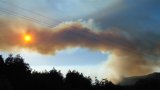
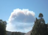
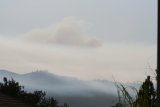
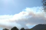
Colina Fire in De Luz at 430 Acres Burned; 50% Contained Tuesday (photos)
Posted September 11, 2007, 2:42 PM.As of 10am this morning, the Colina Wildfire in the De Luz are had burned 430 acres and was 50% contained, according to the Riverside County Fire Department. 700 firefighters were assigned to the fire, and had made substantial progress overnight in surrounding it. Full containment was expected by 8am Wednesday, September 12th. Several homes along Carancho, west of Los Gatos, were threatened last night by the wildfire. No structures were reported damaged or lost as of Tuesday morning. Unlike Monday, smoke from the fire was not drifting east over the Temecula Valley. Carancho Road remained closed from the San Diego/Riverside county line to Calle Colina. Residents were being let back into the area Tuesday morning with proper identification. Other roads in the De Luz area were open. The cause of the fire was a vehicle accident, which occurred in the 2pm hour on Monday. Officials were looking for information on a black, four door Honda spotted in the area. Thanks to Dave Norton who contributed to this story. Photos are courtesy of Dave Norton, Stan Fader, Bruce Reid and Doug Leany. De Luz


Temecula
|
Other Recent Weather News for De Luz, California
|