70°F / 50°F
2 mph SE
0.00"
Storm totals: February 25th-27th, 2011 (updated)
Posted February 27, 2011, 12:22 PM.The coldest storm in two years delivered an arctic blast to Southern California's inland valleys, along with heavy rain, periods of hail, and snow down to the 1,300 foot level, and widespread frost in its wake. Most of the rain fell late Friday night and early Saturday morning, as the cold front moved through the region. Snow fell in the Beaumont area, there was a report of brief snow in Perris Saturday morning (at 1,300 feet elevation), and sleet mixed with rain was reported in Temecula at the Promenade mall later in the morning. Scattered showers marked Saturday afternoon, with hail and some graupel coming down briefly in many locations, including Moreno Valley, San Jacinto, Fallbrook, Temecula, Redlands and Valley Center. Some mountain locations reported two feet of fresh snow. There were only a few scattered showers Saturday night, when snow levels were predicted to fall even further. As a result, snowfall that may have reached many inland valley locations did not materialize. There was, however, a power outage reported in the Temecula area around 3:30am (thanks Victor Arbuzow). Rain for the storm ranged from just under one inch (Moreno Valley was lowest with 0.90") to 2.25" (in De Luz). Other significant rainfall totals were in Murrieta (1.82"), Temecula and Beaumont (1.67"), Fallbrook (1.52"), San Bernardino (1.49"), Lake Elsinore (1.44") and Wildomar (1.41"). A few WeatherCurrents stations passed the 20" mark for the season during the storm: Fallbrook (21.00"), Lake Elsinore (20.71") and Temecula (20.10"). De Luz was already over twenty inches and continued to lead at 27.80". The season totals are the highest since the epic 2004-2005 rain season. For Temecula, it's the second wettest season in the past decade, with records back to 2001. The following rainfall totals were recorded Friday through Sunday:
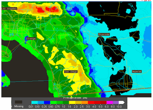
48 Hour Precipitation Map (courtesy National Weather Service) |
Other Recent Weather News for Riverside (Presidential Park), California
|