Currently
67°F
in Murrieta, California, USA
75°F / 50°F
10 mph SW
0.00"
Thursday, April 18, 2024 5:47 PM PDT
Murrieta
Currently
Forecast
Past Weather
Climate
Last 36 Hours
Weather News
Features
F.A.Q.
Contact Us
Use °C/Metric
 RSS Feed
 Follow UsWeatherCurrents
Local Roundup
Mobile Access
On Your Site
Follow UsWeatherCurrents
Local Roundup
Mobile Access
On Your Site
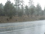
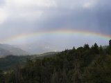
Labor Day Weekend Thunderstorm Pictures From Near Big Bear
Posted October 17, 2007, 7:56 AM.Taken by Temecula resident Bob Hagel, these two pictures show conditions on Highway 38 in the San Bernardino mountains, east of Big Bear, on August 31st, when heat and moisture were combining into heavy thunderstorms. The mountains often receive the worst downpours during the monsoon season, and this day was no exception. "The rain was coming down so hard we had to pull over as I couldn't see the road, " said Bob. "We even reported a fire caused by lightening. Even with the rain the forest is still highly susceptible to fire." The temperature at the time the pictures was taken was 55°F. Meanwhile, it was over 100°F in Temecula and most of the surrounding communities. Heavy rain from a severe thunderstorm, as well as a funnel cloud, were reported in Lake Elsinore later that afternoon. San Bernardino Mountains
|
Other Recent Weather News for Murrieta, California
|