Currently
53°F
in Murrieta, California, USA
71°F / 43°F
2 mph SW
0.01"
Monday, April 15, 2024 10:56 PM PDT
Murrieta
Currently
Forecast
Past Weather
Climate
Last 36 Hours
Weather News
Features
F.A.Q.
Contact Us
Use °C/Metric
 RSS Feed
 Follow UsWeatherCurrents
Local Roundup
Mobile Access
On Your Site
Follow UsWeatherCurrents
Local Roundup
Mobile Access
On Your Site
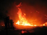
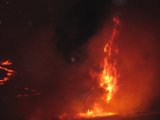
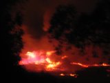
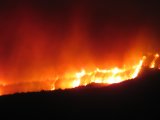
Smoke, Ash Result of Second Fire in Badlands in Two Weeks (updated with photos)
Posted October 6, 2005, 9:02 AM.Smoke and ash Thursday morning in western Riverside County is the the result of a wildfire in the San Timoteo Canyon that began Wednesday. The Woodhouse Fire, as it has been named is the second in two weeks in the area, which is in northern Riverside County near Beaumont, south of Calimesa, and east of Moreno Valley. Over 6,000 acres had been burned by Thursday morning, and 700 firefighters were fighting the blaze. No structures have been damaged, but there many threatened and voluntary evacuations were taking place in the area. The fire was 25% contained as of 6pm Wednesday. State Route 60 through the area, east of Moreno Valley, was closed yesterday in both directions while firefighters battled the blaze. The San Timoteo wildfire burned over 1,100 acres in the area during last week's Santa Ana winds. Photos are courtesy of SoCalWeather.net. Badlands (near Moreno Valley)
|
Other Recent Weather News for Murrieta, California
|