Currently
N/A°F
in De Luz, California, USA

N/A°F / N/A°F
N/A
N/A
Thursday, April 18, 2024 8:58 AM PDT
De Luz
Currently
Forecast
Past Weather
Climate
Last 36 Hours
Weather News
Features
F.A.Q.
Contact Us
Use °C/Metric
 RSS Feed
 Follow UsWeatherCurrents
Local Roundup
Mobile Access
On Your Site
Follow UsWeatherCurrents
Local Roundup
Mobile Access
On Your Site
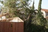
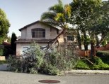
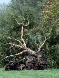
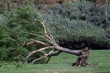
High Winds Cause Damage (photos)
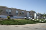
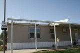
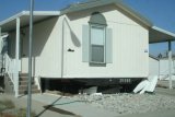
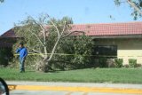
Posted October 22, 2007, 10:18 AM.Strong Santa Ana winds caused widespread damage in the San Jacinto and Temecula Valleys overnight. Damage included many uprooted and snapped trees, as well as leaves and trash everywhere. In San Jacinto, a sand storm was reported Sunday evening that brought visibility to near-zero. Wind gust speeds there were recorded at 29 mph before a power outage took down reports from the weather station there. The top wind gusts were reported at WeatherCurrents' Fallbrook location, which recorded 73 mph last night, an all-time record. The extent of the damage in Fallbrook from the severe wind was unknown as of Monday morning. At the Temecula weather station, top gusts of 54 mph. The 54 mph was a record for the station, where wind data has been captured dating back all the way to 2001. Other top wind gusts recorded were 34 mph in Murrieta, 49 mph in Perris, 34 mph in Riverside, 34 mph in Lake Elsinore, 30 mph in Sun City, and 34 mph in De Luz. Photos are courtesy of William Todd. Temecula
San Jacinto
|
Other Recent Weather News for De Luz, California
|