Currently
N/A°F
in De Luz, California, USA

N/A°F / N/A°F
N/A
N/A
Friday, April 19, 2024 4:41 PM PDT
De Luz
Currently
Forecast
Past Weather
Climate
Last 36 Hours
Weather News
Features
F.A.Q.
Contact Us
Use °C/Metric
 RSS Feed
 Follow UsWeatherCurrents
Local Roundup
Mobile Access
On Your Site
Follow UsWeatherCurrents
Local Roundup
Mobile Access
On Your Site
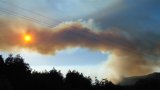
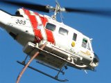
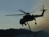
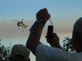
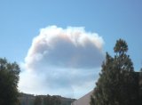
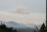
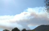
300 Acre De Luz Brush Fire Sends Smoke Over Temecula Valley Monday (photos)
Posted September 10, 2007, 8:31 PM.A brushfire west of Temecula, in De Luz not far from WeatherCurrents' De Luz weather station, sent heavy smoke over the Temecula Valley Monday afternoon. At 7pm, the fire was burning in an easterly direction, with 300 acres of grass and medium brush consumed. No structures were threatened, and the fire was considered out of control. The fire was burning near De Luz and Carancho Roads. The intersection of both roads was closed Monday evening, as were Tenaja and De Luz, and Via Volcano and De Luz. The origin of the fire was near Carancho and Calle Colina, in the 2pm hour. 320 firefighters were on the scene. Air tankers and helicopters were assisting. Photos were contributed by Dave Norton, Doug Leany, Stan Fader and Bruce Reid. De Luz
Temecula
|
Other Recent Weather News for De Luz, California
|